Ascii files
333,579 space deliminated ascii files
One each 1/16 degree land point: 14N to 53N, -125E to -67E
Columns: P Tmax Tmin wind
23,376 rows: the number of days from Jan 1 1950 to Dec 31 2013
Named data_lat_lon
Download dropbox file File with 333,579 file names, livneh_urls.txt
Download script Uses livneh_urls.tex files names
Run with: chmod +x script.sh && ./script.sh
Paper Livneh et al. (2015)
netCDF files
precip directory contains the extreme precipitation preserving precipitation netCDF for each year
temp_and_wind directory contains the Tmax, Tmin, and Wind netCDF for each year
get_livneh_ex.sh code used to download netCDF from original site
get_livneh_ex_columbia.sh code used to download netCDF from Magog
GitHub repository VICpy
netcdf2vic.py script
raw netcdf2vic.py script
VIC 4.06 modified for netCDF input/output
An Extreme-Preserving Long-Term Gridded Daily Precipitation Dataset for the Conterminous United States
Extreme-Preserving Livneh Precipitation Movie
MPI-ESM1-2-HR
A middle-of-the-road model, not at the cold–wet or hot–dry extremes in the ensemble mean, this is one ensemble member
Regridded to the Livneh grid, with bilinear interpolation for temperature and wind and area-conserving remapping for precipitation
222,455 space deliminated ascii files per directory
Less files as strict CONUS only (Livneh has some southern Canada and northern Mexico)
Columns: P Tmax Tmin wind
14610 rows: the number of days from Jan 1 1980 to Dec 31 2019
Named data_lat_lon
DBCCA: statistical downscaling method, Daily Bias Correction and Constructed Analogues
RegCM: dynamical downscaling method, Regional Climate Model
_Livneh: Livneh target dataset
_Daymet: Daymet target dataset
Download dropbox file File with 222,455 file names, model_urls.txt for RegCM_Livneh
For other files replace RegCM_Livneh with
DBCCA_Livneh
RegCM_Daymet
DBCCA_Daymet
CNRM-ESM2-1
A colder and wetter model in the ensemble mean, this is one ensemble member
Same format as above
ACCESS-CM2
A warmer and drier model in the ensemble mean, this is one ensemble member
Same format as above
MRI-ESM2-0
Also strong warming in the ensemble mean, this is one ensemble member
Same format as above
BCC-CSM2-MR
Dry summer bias in the ensemble mean, this is one ensemble member
Same format as above
NorESM2-MM
Slightly cool/wet bias in the ensemble mean, this is one ensemble member
Same format as above
Download Files Monthly Climate Files and Streamflow
| Basin Piece | Basin Definition | Station | Agency | Station ID | Code Variable |
|---|---|---|---|---|---|
| 1. Upper Mississippi | Mississippi upstream of Missouri confluence | Mississippi River at Grafton, IL | USGS | 05587450 | Q_upper_mississippi |
| 2. Lower Mississippi | Mainstem downstream closure | Mississippi River at Tarbert Landing (Discharge) | USACE | 01100Q | Q_lower_mississippi_tarbert |
| 3. Missouri | Missouri River basin | Missouri River at Hermann, MO | USGS | 06934500 | Q_missouri |
| 4. Ohio | Ohio River basin (excluding Tennessee) | Ohio River at Metropolis, IL | USGS | 03611500 | Q_ohio_metropolis |
| 5. Tennessee | Tennessee River basin | Tennessee River at Hwy 60 near Paducah, KY | USGS | 03609500 | Q_tennessee |
| 6. Arkansas–White | Arkansas + White basin contribution | Arkansas River at Little Rock, AR | USGS | 07263450 | Q_arkansas_white |
| 7. Red | Red River basin, Excluded from Tarbert discharge; included for navigation. | Red River at Alexandria, LA | USGS | 07355500 | Q_red |
Open Google Drive for papers/chapters on 1927 Flood
Google books, Monthly Weather Review Report of the 1927 Floods
Google books, The Improvement of the Lower Mississippi for Flood Control and Navigation, 1932
Tulane access under institution, Improvement of Navigation In Relation to Flood Control, 1929
Tulane access, Resume of the Mississippi River Flood Problem, 1929
Palmer Drought Severity Index (PDSI)
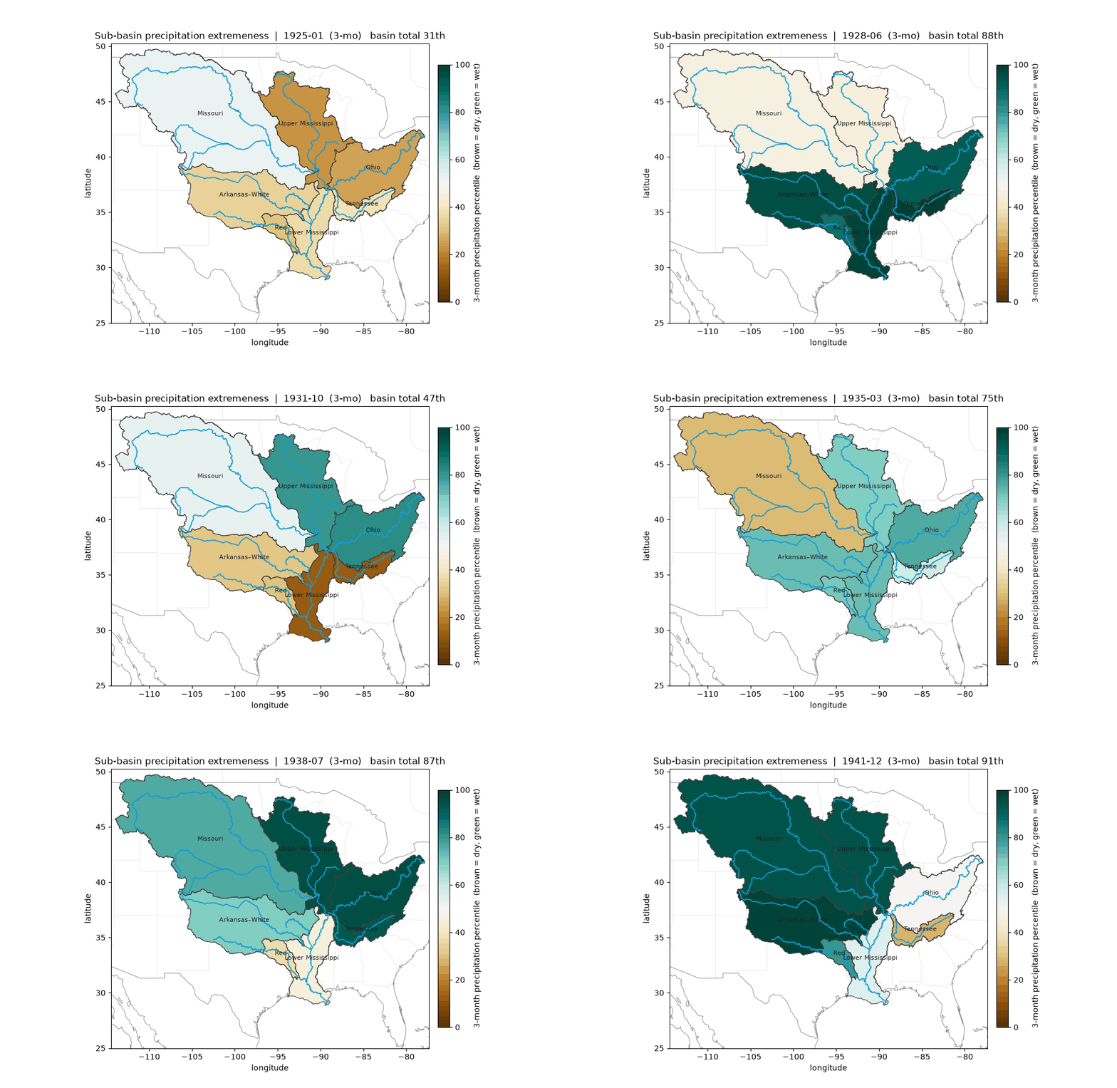
CRU Precipitation Percentiles (model input) 3 months (scale of +, and short -)
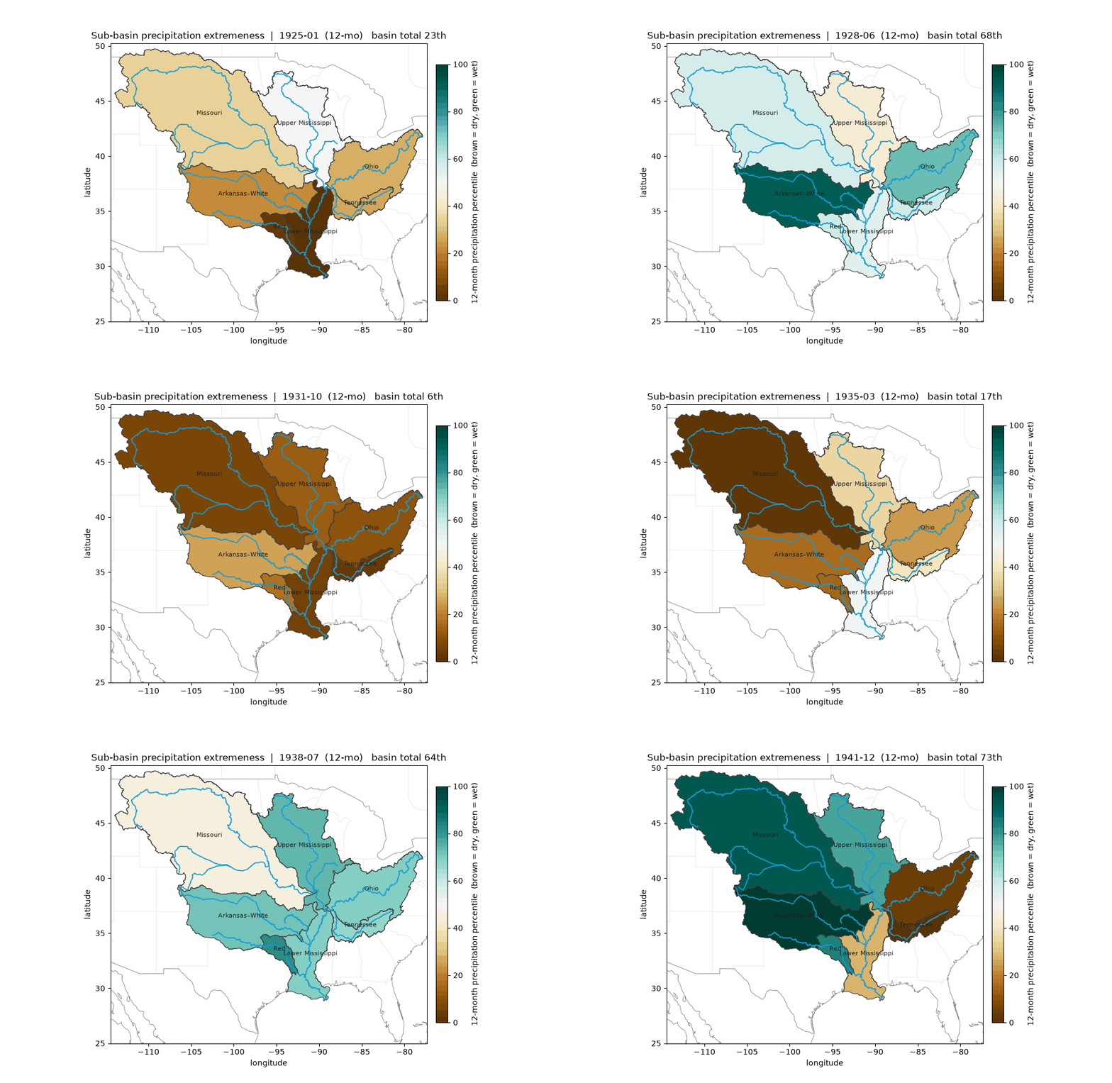
CRU Precipitation Percentiles (model input) 12 months (scale of long -)